
Riverbend Park
") Riverbend has been by far one of our favorite places to hike, of late. There are expansive networks of trails (for the beginner as well as for the more experienced explorer), including the Ocean-to-Lake portion of the Florida Trail. A wonderful extension of the Florida Trail can also be picked up across the street from Riverbend — accessible through the park (under Indiantown Rd.), or creatively hoofing it across the street, near the river. We jump a fence for quicker and easier access, but it can be difficult to find if you don’t know what you’re looking for. It’s a fantastic trail, with a gorgeous watering hole, canopy trees, and miles of hiking, that leads to Jonathan Dickinson. (Several pics below were taken along this trail.)
Riverbend has been by far one of our favorite places to hike, of late. There are expansive networks of trails (for the beginner as well as for the more experienced explorer), including the Ocean-to-Lake portion of the Florida Trail. A wonderful extension of the Florida Trail can also be picked up across the street from Riverbend — accessible through the park (under Indiantown Rd.), or creatively hoofing it across the street, near the river. We jump a fence for quicker and easier access, but it can be difficult to find if you don’t know what you’re looking for. It’s a fantastic trail, with a gorgeous watering hole, canopy trees, and miles of hiking, that leads to Jonathan Dickinson. (Several pics below were taken along this trail.)
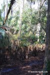
 Within Riverbend proper, besides the nearly 10 miles of hiking and biking trails, there are 7 miles of equestrian trails, and 5 miles of canoeing/kayaking trails — leading you through an otter preserve, and all the way to JD as mentioned. What I especially love about this park is its significant and rich history: Habitation has occurred along the Loxahatchee river dating as far back as the Archaic Period, 5,000 years ago. The first battle of the Loxahatchee, referred to as Powell’s Battle, took place on January 15, 1838. The second battle of the Loxahatchee — Jesup’s Battle — occurred nine days later on January 24, 1838. Outnumbered 1500 to 300, the Seminoles fled into the swamps. After the Battle of the Loxahatchee, Jesup petitioned Washington to allow the Seminoles to remain in the Everglades, effectively ending the war. Washington denied his request, and 600 Seminoles were captured at Fort Jupiter. From its ancient Indian middens, through the tragic Seminole War Battles, to its impressive present-day restoration efforts, tremendous respect should be given to this land and its history. Habitats include beautiful pine flatwoods, open meadows, cypress swamps, oak hammocks, and even abandoned — but still fruit-bearing — orange and grapefruit groves. It can become busy on the weekends, so if you’re able to visit on a weekday during the quieter hours, it’s much more peaceful (or, visit the less-traveled Florida Trail extensions). We’ve seen great horned owls, red-shouldered hawks, deer, alligator, wild turkey, peacocks, gopher tortoises, and otter during such off-times.
We’ll picnic here, along the river or within park in the chickee huts, before our hikes. As always, bring extra trash bags, in case there are no cans in sight until the park’s entrance. (Although here, that’s not such a problem.) We often pick up others’ trash along the way, anyways.
For More Information:
- Trail of Florida’s Indian Heritage
- Loxahatchee Battlefield Preservationists
- Riverbend Park
- Riverbend Park
-

- Peacocks roam the grounds at Riverbend Park
-

- Pretty Peacock in the Daisies, Riverbend Park
-

- Sand crane, part of the local family that lives at Riverbend

-

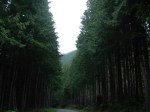
- Typical large pathway at Riverbend Park
-

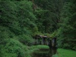
- Old Homestead, Riverbend Park

-

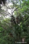
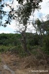
- Lovely Trees at the Seminole Battle Sites, Riverbend Park
-

- Beautiful trees among the old battlegrounds of Riverbend Park

-

- Large trails at Riverbend Park

-

- Lake/Swamps in Riverbend Park


-
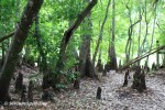
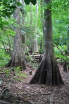
- Cypress swamps, Riverbend Park
-

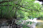
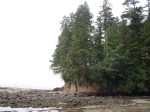
- Off-trail river, Riverbend Park
-

- Off-trail lake, Riverbend Park


-

- Crossing into the FL Trail from Riverbend Park (Across Indiantown Rd)


")
, with Rock Outcroppings")


")


")
")


