
Jonathan Dickinson State Park: Strolling JD to Riverbend
Jonathan Dickinson State Park offers an ideal exploration of natural Florida, providing a vast ecosystem filled with wildlife in 13 natural communities. Sand pine scrub, pine flatwoods, mangroves, and cypress swamps cover the entirety of the park, nearly 20 percent of which is comprised of coastal sand pine scrub, an environmental community so rare that it’s been designated as “globally imperiled.” The Loxahatchee River — Seminole for “River of Turtles” — was federally designated as Florida’s first “Wild and Scenic River” in 1985, and runs through Jonathan Dickinson, originating in Riverbend Park to the south.
 A portion of the Florida Trail winds throughout the park, but be sure to double-check its start points — they’ve recently altered one of them. It includes two interconnecting hiking loops — the East Loop and the Kitching Creek Loop (see trail guides within the links, below). Each are provided with their own primitive campsites — something we’d like to do while the weather holds. The loops are linked via a short connector trail through pine flatwoods, and are popular with hikers and backpackers due to the fact that they’re the furthest campsites from the park’s entrance. The total hiking distance for both loops is 17 miles. While we haven’t yet done both simultaneously, we’ve done them separately — and we’re in the process of investigating the portion of the Florida Trail leading to Riverbend Park.
 It was a perfect day for such an exploration — overcast. Four hours of hiking Jo
 nathan Dickinson’s terrain, and one is thankful for cloudy skies (or at least my Irish skin always is). After passing stately rows of centuries-old cypress and live oak along the Loxahatchee River (into which the Kitching Creek flows), we headed into the lovely cypress swamps — always my favorite — before breaking out once again into the open pine flatwoods. We only saw one other backpacker on his way to the primitive campsite, in the late afternoon — outside of the family of feral pigs (wild hogs) and myriad birds (we tried looking for the maniacal owl), that is. We’ll definitely be returning to complete the hike, and soon.
For More Information:
- Jonathan Dickinson State Park
- Jonathan Dickinson State Park Trails
- Jonathan Dickinson State Park – Kitching Creek Loop Trail
- Jonathan Dickinson State Park (Wikipedia)
- Jonathan Dickinson State Park (Florida State Parks)
- Friends of Jonathan Dickinson State Park
- Facebook Page

Kitching Creek, Jonathan Dickinson State Park

Signage for the Casual Hikers, Jonathan Dickinson State Park

Heading into the Cypress Swamp, Jonathan Dickinson State Park

Controlled Burn Results, Jonathan Dickinson State Park


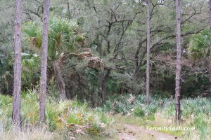
Cypress Swamp, Jonathan Dickinson

Cypress Knees, Jonathan Dickinson State Park

Swamp, Jonathan Dickinson State Park

Cypress Swamp, Jonathan Dickinson State Park

Cypress Swamp, Jonathan Dickinson State Park

Slash Pine Bark, Jonathan Dickinson State Park

Trail Signage, Jonathan Dickinson State Park

Slash Pine Treetops, Jonathan Dickinson State Park

Signage to Riverbend, Jonathan Dickinson State Park


Hi, I was hiking from Riverbend Park to the Kitchen Creek campsite one day in mid-February. I met you and another man about 5 minutes north of the Hobe Ditch. I mentioned the ditch to you since I scraped my ankle there on an underwater log. You and your friend said you were staying at the KC campsite but were presently going to go to Indiantown Rd. and then return.
I never ran into you all again that day. Did you cross the Hobe Ditch and go all the way to Indiantown Rd?
Oh, hey there — I do remember, it’s great ‘seeing’ you again, hah! We ended up hiking another good hour past Hobe Ditch, before making the return trip (which is when we ran into you). It was a long day.
How long did it take you from Riverbend to the KC campsite? As many times as we’ve done JD and the FL Trail across from Riverbend, we’ve never done that particular segment (which was what we were scouting)…
Glad you remember the old man. I cannot believe I found your photo online. As soon as I saw your picture, I knew you were the person I ran into that day. The one way trip from Riverbend Park to the KC campsite (7 miles) took me 3 hours. I ate lunch at your campsite and then walked back to Riverbend Park.
The Hobe Ditch was kinda deep when I crossed it. I figured you were going in up to your armpits that day. HaHa
Hope to see you again!
WOW… That’s quite a day-hike! And we were complaining, hahhh! We did the opposite as you, looping from the JD end, but next time we’ll definitely investigate the Riverbend – KC route (please hold, weather), so thanks for the info!! “Old man” my heinie, lol… I was just talking about the need to return to “hiking condition” after a 5-hr stint in Bluefield. 🙂
I’m so glad you found this; it began as a desire to track my images and hikes, and to help spread the info (b/c we were researching as well). Knowledge = preservation of these spaces, with any luck. For sure, hope to see you again!!